Course Description
(all distances approximate)
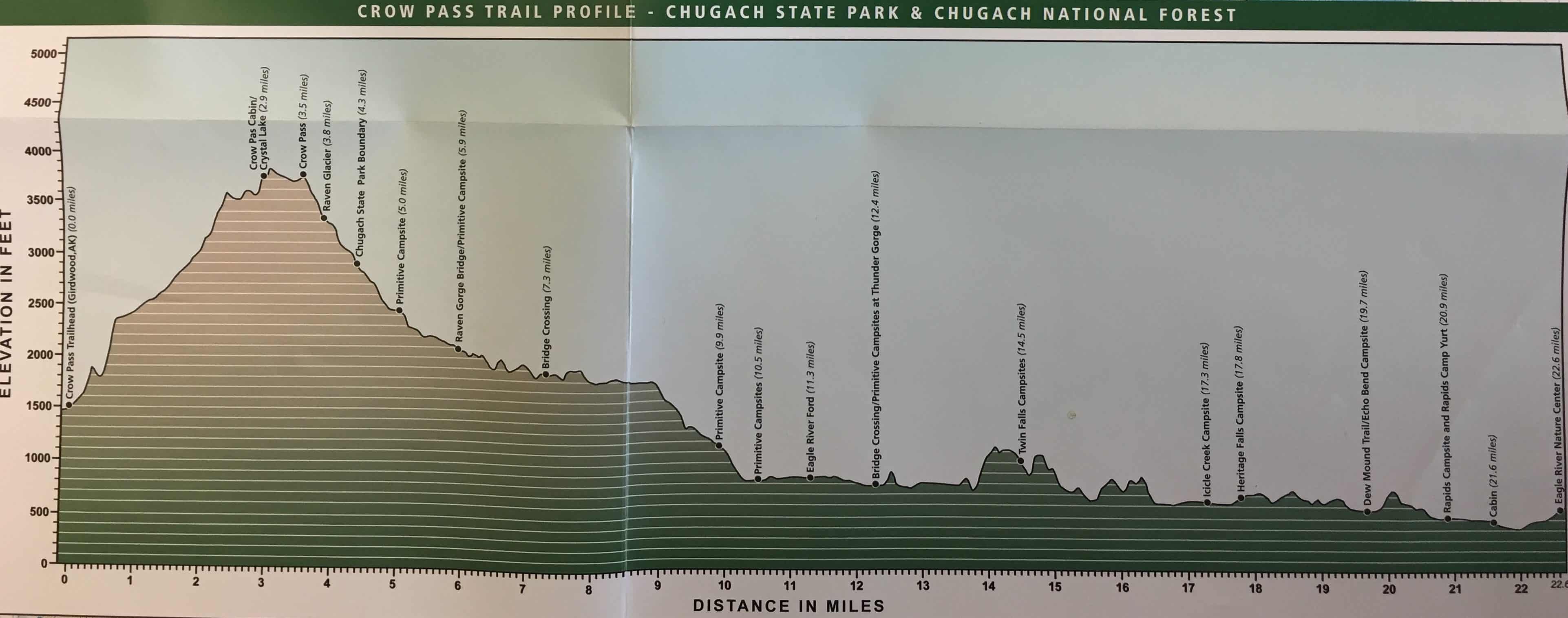
The Crow Pass Crossing is divided into two virtually equidistant halves — but they are very different in character.
Immediately upon leaving the Crow Creek Trailhead, the route climbs steadily for 3.5 miles to the actual Crow Pass. The full race trail gains about 3,200 feet and approximately 2,200 feet of this comes in the initial climb.
One of the only trail markers you’ll see is a signing at a junction about 1.5 miles into the race directing you to go straight up the valley toward the “Mine Ruins” (do NOT turn right here: the “high traverse” route is much longer).
On the way to the pass, runners go by gold-mining ruins from the Monarch Mine, which operated from 1906-1948. Near the mine will be some trail markers and pin flags; make sure to follow the designated route here as required by the U.S. Forest Service.
Shortly before the pass, runners will may see the Crow Pass Cabin on their left managed by the Chugach National Forest; the cabin and outhouse are off-limits for racers! In some years, runners will encounter considerable snow en route to the pass.
In 2021, a public outhouse was installed in this area near the trail that racers can use.
A racer must reach the Pass (elevation 3,642 feet) in less than 60 minutes to continue.
At the Pass begins a 7-mile descent to the Eagle River. Near Mile 4, racers exit the Chugach National Forest and enter Chugach State Park, where they will remain for the duration of the course. Early during the descent are 3-5 short but steeply sloped snowfields that must be navigated. Typically, a somewhat flat path has been created by previous travelers, but losing the path or one’s footing risks a potentially disastrous slide down a snowfield into a boulder field.
After descending the final snowfield (or the adjacent rocky path), racers pick up the main trail down Raven Creek Valley. The first major landmark is a bridge over Raven Gorge (Mile 5.9) followed by another over Turbid Creek at Mile 7.3. Then the brush gets higher and runners spend several miles running (or walking) on faith, as waist- to chest-high vegetation obscures the chunky-rocked trail underfoot (they’ll also encounter cow parsnip and stinging nettle).
Runners will first see the Eagle River between miles 10 and 11. Do not cross the river at first sight, but turn right and continue upriver to the Ford Site at Mile 11.3, where a volunteers will check your name off a roster and offer basic guidance if needed.
Crossing the river — estimated at 150-200 feet from bank to bank — is exhilarating, freezing, no big deal or potentially dangerous, depending on the person, their experience, their height and the river level on any given day (the depth can range from shin to chest-deep). Some racers link arms or put their arms over each other’s shoulders for extra stability; volunteers are NOT there to escort racers across, but a Alaska Mountain Rescue Group personnel will be staged slightly downriver with throw ropes if a racer is swept off their feet.
This four-minute video about fording the river is geared toward hikers but has valuable information about how to cross.
Aim for the white post on the far side of the river. Once there, take a hard left, run for a few seconds and turn right onto a singletrack trail. Once across, racers try to regain feeling in their numb legs as sections of the course become less technical and mostly flat.
While bears can be encountered anywhere along the trail, the second half in the Eagle River Valley is more forested and thus more prominent bear country (bees are also more prevalent). Runners should stay alert and not wear headphones.
Thunder Gorge (Mile 12.4) can be deep and rapidly flowing; it has a rope to assist in crossing the creek. However, if you go downriver about 35 yards from the rope, the creek braids and becomes much shallower, so this may be a better crossing point.
After Thunder Gorge, there is a dry creek area marked by rock cairns, Twin Falls and its campsites, the infamous “Chutes and Ladders” section and a boulder field (with a secondary adjacent path, take your pick). Then you’ll reach Icicle Creek (Mile 17.3), where a bridge was built in 2020 that eliminates the need to wade across.
The first major landmark after Icicle Creek is The Perch, a gathering spot for spectators. About four miles from the finish, it’s a steep slab of rock with a scenic view of the valley. A new, longer trail has been built that rises above and then drops down to The Perch. The old, more direct trail is now blocked and off-limits.
One mile later is Echo Bend (Mile 19.7), where a maze of trails managed by the Eagle River Nature Center begins. Stick to the main trail and signs that point to the Nature Center or Visitor Center.
The last few miles, despite a “rock garden” that can trip you up, are among the easiest terrain-wise, although the 20 miles in your legs make it feel less so.
Then the trail widens and when you first hit the boardwalk, you’re less than a mile from the finish. The last stretch is the final insult, a half-mile of uphill until the finish line and Nature Center appear with little warning.
Congrats, you’ve completed the Crow Pass Crossing, no small feat!